 | BELIZE NATIONAL PARKS, NATURAL RESERVES, & WILDLIFE SANCTUARIES |

CROOKED TREE WILDLIFE SANCTUARY
WHAT TO SEE
This mosaic of elongated lagoons, connected by creeks,
savannas and logwood thickets is excellent for birds. As the dry season gets
underway, they arrive in huge numbers from the Peten and Yucatan as
swamps in these areas dry up. By April, the Crooked Tree landscape is
alive with flocks of different water birds. Huge congregations
of
Double
Crested Cormorants, Egrets, Herons, and different ducks all can be seen.
The Jabiru Stork, the largest bird in the Americas, also calls in from time to
time. They appear in November, build their stick nesting platforms in
December or January, and raise their young by June. Where they spend the
rest
of
the year is a bit of a mystery, but the suspicion is Campeche in
Mexico.
 Crooked Tree also hosts the Peregrine, the world's fastest falcon. They
patrol the waterways in search of a meal and have learnt to follow tour
boats. The many Coots on the water are distracted when the boats pass,
giving the Peregrine a chance to search out their prey, dive and strike.
Powerful enough to grab an adult Coot right out of the water, the Peregrine
carries its meal off to some perch.
Crooked Tree also hosts the Peregrine, the world's fastest falcon. They
patrol the waterways in search of a meal and have learnt to follow tour
boats. The many Coots on the water are distracted when the boats pass,
giving the Peregrine a chance to search out their prey, dive and strike.
Powerful enough to grab an adult Coot right out of the water, the Peregrine
carries its meal off to some perch.
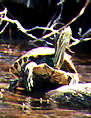
Another Crooked Tree bird spectacle is the Snail Kites, feeding on Apple
Snails whose large sun-bleached shells litter the banks. Their white egg
clusters are also often to be seen on sedges and rushes, just above the
waterline. The Kites hover round the sanctuary year round and are one
of
its
characteristic animals.
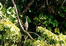
Other permanent inhabitants include all
Belize's species of kingfishers, and
Muscovy and Black-bellied Whistling
ducks that nest in the trees around the
lagoons. Black Creek or Spanish Creek
offer particular good birding, as they
meander south to the Belize River.
Colonies of Boatbilled Herons can be
found. Hard to see but not to hear, they
hide away in the darkest recesses of the
canopy, but give themselves away with
their squawking cackling calls. Along the
rivers banks also look out for crocodiles,
turtles and iguanas. In the middle of the
sanctuary sites Crooked Tree itself Native
cashew trees abound. Look out for the
bright red Vermilion Flycatcher. It's hard
to miss as it sits on fence posts waiting for
passing insects.
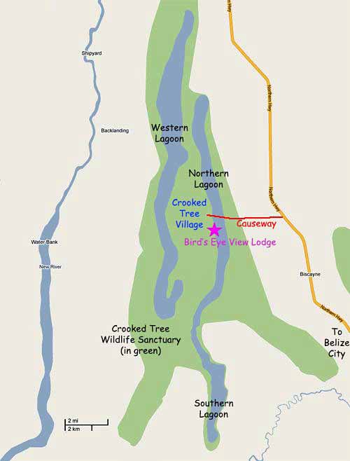
GETTING THERE
The turn off to Crooked Tree is on the west side of
the Northern Highway at Mile 33. It's a dirt road marked by a wooden
signpost. If you're coming by a Belize City/Orange Walk/Corozal bus it will
drop you off here, which leaves you a two mile stretch to hitch or walk, or
there is a direct bus to Crooked Tree village from Belize City. Tour
companies also run trips to the Sanctuary from the City and some northern
hotels. A range of accommodation is available in Crooked Tree.
The new visitor centre is on the left of the road, a green and white building
just before you cross Crooked Tree Lagoon. This is where you have to
report in.
Half a day is enough for a visit to the sanctuary, but those really into birds
can easily take a day or more exploring the waterways and the village.
WHEN TO GO
Although good anytime in the dry season, the greatest
concentration of birds is around April. If you want a boat ride, it's better to
come a few weeks earlier otherwise the water is too shallow, and you have
to do your bird watching on foot.
VISITOR FACILITIES
To really get the most out of a visit to Crooked
Tree, you need to get out on the water. Check at the visitor centre for
advice about hiring a boat and a guide from the village. The sanctuary is
open seven days a week, from 8am to 4pm. Basic trails are laid out,
following the shoreline and village tracks. The Jacana Loop Trail, Trogon
Trail and Limpkin Trail are good for wildlife. Belizeans pay an entrance fee
of $2 and foreigners $8. Crooked Tree is managed by the Belize Audubon
Society.
 The site's first visitor centre was built in 1984, equipped with interpretative materials in
1986. A new facility has been opened in 1995 and is located at a new administrative area across the lagoon near the
eastern boundary. A trail network has been established using existing village roads and tracks, and a self-guiding
map can be bought. Eco-tourism has encouraged the construction of 4 small hotels and there are 3 guest houses.
Locals provide guide and boat trip services. Visitor numbers are given below, although these are under-estimates as
not all visitors are recorded. Roughly 30% of foreigners
fail
to sign, arriving in large groups by minibus.
The site's first visitor centre was built in 1984, equipped with interpretative materials in
1986. A new facility has been opened in 1995 and is located at a new administrative area across the lagoon near the
eastern boundary. A trail network has been established using existing village roads and tracks, and a self-guiding
map can be bought. Eco-tourism has encouraged the construction of 4 small hotels and there are 3 guest houses.
Locals provide guide and boat trip services. Visitor numbers are given below, although these are under-estimates as
not all visitors are recorded. Roughly 30% of foreigners
fail
to sign, arriving in large groups by minibus.
ESTABLISHMENT HISTORY
Following recommendations by Waight (1968), FAO (1978) and the
BAS, the site was designated in December 1984 (SI 95).
CURRENT AREA
The sanctuary's area is difficult to determine accurately because:
the boundary description given in the
SI
is confusing and sometimes conflicting.
the sanctuary is delineated by a set distance (300 feet) above high water mark or by this distance
'inland'. Neither are accurately mapped, and in any case are highly variable throughout the year.
along the frontage of the village, this reserve strip overlaps private property.
the sanctuary comprises 2 parts, both of which are complex seasonally fluctuating wetlands, so the
lack of boundary clarity affects both.
In the light of these considerations, it is no surprise that no attempt at estimating the total area was
made in the SI. Based on its coordinates and boundary description the GIS calculation gives 41297
acres.
JUSTIFICATION
To protect this wetland complex that acts as an important dry season refugia for
resident and migrating wildfowl.
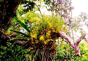
HABITATS
Freshwater lagoons, marsh forest, broadleaf forest, pine/oak savanna and homestead
farms.
HOLDRIDGE LIFE ZONE
Subtropical Moist.
ZOOGEOGRAPHICAL AFFINITIES
Unknown, but possible Yucatan influence.
WILDLIFE
This site is of major importance for waterfowl, both waterfowl and local (northern Belize, the Peten of
Guatemala and southern. Mexico). Of particular interest is the small number of nesting Jabiru each year. In total,
276 species have been spotted at Crooked Tree. As well as the bird life, Crooked Tree holds a growing number of
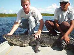
Morelet's Crocodile. Other mammals include black bowler monkeys and Central American otters. All Belize's
species of freshwater turtle are found in the Reserve. Partially surrounding the lagoons is a Logwood
savannah/swamp, the largest continuous stand of these trees remaining in. Belize. Marsh, semi-evergreen/deciduous
broadleaf forest, pine/oak savannah and pasture are the other vegetation communities in the sanctuary, along with
abundant submergent aquatic vegetation in the lagoons.
LOCAL POPULATION
Crooked Tree village (fishing and cattle raising) (population approximately 595) is
surrounded by the sanctuary and its wetlands. The village covers roughly 2.5 square miles, out of the 19.3 sq. mile
island Until the construction of the causeway in 1983, the village was only accessible by boat The nearest other
significant settlements are Lemonal (population 117) to the southwest on Spanish Creek, Biscayne (population
319) the same distance west, and Bermudian Landing (population 146) 5 miles south. Belize City is 30 miles
southwest down the Northern Highway.
PHYSICAL FEATURES & CLIMATE
This lowland area on the northern coastal plane is an extensive complex of
shallow lagoons streams, rivers and marshes, overlying alluvial deposits of siliceous sand and beds of impermeable
clay. The site centres around 2 groups of lagoons; the first consists of Calabash Pond, Revenge, Western Crooked
Tree and Southern Lagoons, and Spanish Creek which are all linked to Belize River, via Black Creek, the second
consists of Jones and Mexico Lagoons, which also link into the Belize River via Mexico Creek When the Belize
River is in flood, the resew acts as an overflow basin. Similarly, when Cayo District has rain the water back-tracks
up through Spanish and Black Creek. At these times, Crooked Tree (Northern) Lagoon reaches as greatest depth,
usually in December in the region of 8 feet. Then by May, the lagoon can be completely dried out. On average 50-
80 inches of ram a year fall on the Crooked Tree area, mainly outside the January to April or May dry season,
when the rainfall is approximately 4 inches a month. At this time, the level of the lagoons
falls
considerably,
and some temporarily dry up, reducing the lagoon area by two-thirds in especially dry years. Usually, only
Crooked Tree Lagoon, Southern Lagoon and Black and Spanish Creeks remain. It should however, be noted that
hydrological data on this extremely complex wetland are lacking . In June 1975, rain was sufficiently low for the
entire water complex to go completely dry. The sanctuary is roughly 10-16 feet above sea level. The mean monthly
minimum temperature in winter is 61C and 75C in summer, with maximums of 82C in winter and 91C in summer.
CULTURAL FEATURES
The Logwood forests in the area were used to produce 7 different colour dyes
including haematoxylin for export to Europe. Crooked Tree Village was settled for this purpose in
approximately 1750, making it perhaps the earliest
inland
European settlement in Belize. The logs were
floated down Black Creek to the Belize River. The sanctuary also has a Mayan site, Chan Hiix, at the
southwestern comer of Western Lagoon. Its excavation has only recently started.
Click here for more information on Crooked Tree....
| BELIZE NATIONAL PARKS, NATURAL RESERVES, & WILDLIFE SANCTUARIES |
Belize Parks Home /
Bacalar Chico /
Bird Sanctuaries /
Burdon Canal Nature Reserve /
Blue Hole National Park /
Great Blue Hole, Lighthouse Reef /
Chiquibul National Park and Caracol /
Cockscomb Wildlife Sanctuary /
Columbia River Forest Reserve /
Community Baboon Sanctuary /
Crooked Tree Wildlife Sanctuary /
Five Blues Lake National Park /
Glover's Reef Marine Reserve / Guanacaste National Park /
Half Moon Caye Natural Monument /
Hol Chan Marine Reserve /
Laughing Bird Caye /
Marco Gonzales /
Mexico Rocks /
Mountain Pine Ridge Forest Reserve /
Payne's Creek National Park /
Rio Bravo Conservation and Management Area /
Shark Ray Alley /
Shipstern Nature Reserve /
Turneffe Atoll /
|