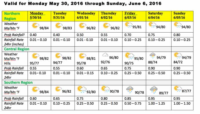
TUESDAY MAY 31 - JUNE 7, 2016
The 2016 Rainy Season will definitely not begin on the first day of June this year. Another week of punishing hot and dry weather will persist before we get some significant and persistent rainfall. The years 2008 and 2003 are two of the analogous years to 2016. So we all have to prepare for the worst and hope for the best this hurricane season. Measured (YSI) and remotely observed SST (satellite sensors) in the western Caribbean are around 30 degrees Celsius or 86 Fahrenheit; a warm pool in the western Caribbean.
Model projections and current atmospheric conditions over the Caribbean and northern Central America indicate that the summer (rainy season) circulation pattern are now in place, with a major Upper Level trough over the central and eastern Caribbean, a tropical wave in the SW Caribbean heading towards Nicaragua, and the Inter-tropical Convergence Zone (ITCZ) bulging northward over Central America this morning (See Fig. 1 Surface weather map). However, no major system is expected to drift over the NW Caribbean and Belize during the next three to five days to generate a persistent rainfall event, marking the onset of the 2016 Rain Season. Hence, the 2016 Rainy Season will be delayed by almost five to seven days. Significant and persistent rainfall will gradually begin by next Monday and continue through Thursday of next week.
The 2016 intense Dry Season will persist at least for the next seven (days). Scattered outbreaks of showers and afternoon thunderstorms are likely to develop over the South and West on Thursday and Friday, increasing on Saturday then decreasing on Sunday and Monday. An upsurge in showers and thunderstorms is forecast for next Tuesday through Thursday, with daily accumulations in excess of an inch particularly in the South, West and some areas of the coastal zone. This activity will be associated with low pressure disturbance in the NW Caribbean and northern Central America, pulling in moisture from the Pacific. This will likely mark the onset of the 2016 Rainy Season over Belize.
CLICK HERE for the whole report
NOAA Outlook for Central America June 1 - 8, 2016
After another week of below-average rainfall, moisture deficits are increasing for many parts of the region.
A pattern of suppressed rainfall was again in place across the region. Observed weekly rainfall according to TRMM was widely 25-100mm below average. Heavy precipitation was confined to the Gulf of Fonseca region, where around 100mm fell. Local parts of southwestern Guatemala received similar amounts. Outside of these areas, rains were generally light. Many parts of northern Guatemala and northern Honduras received nearly no rainfall. With another poor week of rainfall registered, longer-term rainfall deficits continue to deepen and expand over the region. Patchy 30-day deficits of greater than 100mm are scattered throughout the Central American countries. The picture is similarly poor dating back to the beginning of April. In some parts of central Guatemala and northern Honduras less than 25% of normal precipitation has been received. As a result, satellite estimation vegetation indices have indicated degraded ground conditions. These are most apparent in central and northern Guatemala as well as central Honduras. It is expected that an expanding area of cropping activities are likely to be negatively affected by these conditions.
Forecast models indicate that Heavy above-average rains are likely in many central and western portions of the region during the outlook period. The most significant rainfall is likely to be in El Salvador and southern Guatemala where upwards of 300mm could fall. Many other areas of western Nicaragua, southern/central Honduras, El Salvador, and southern Guatemala can expect more than 100mm of rain. Parts of eastern Nicaragua are more likely to receive below-average rain totals closer to 25mm. This pattern should help to alleviate some of the abnormal dryness.


CLICK HERE for the whole report


