|
GEOLOGIC HISTORY OF AMBERGRIS CAYE
Ambergris Caye and the northern part of the Belize mainland, lies within
the geologic area known as the Yucatan Platform. The geologic history of
this area before the Cretaceous Period (some 140 million years ago) is only
partially understood. Apparently the Yucatan Platform and presumably the
Ambergris Caye area was land 195 million years ago and between 195 and 140
million years ago (during the Jurassic Period) the area was slowly inundated
by sea waters and sediments began to be deposited on the platform area.
By 140 million years ago the platform was nearly all under water with limestones
being deposited all across it. The conditions responsible for relatively
continuous deposition of limestones have persisted until fairly recently,
from a geologic point of view. This has resulted in the formation of a thick
sequence of limestones that underlie Ambergris Caye and the northern Belize
mainland. In recent geologic time the area of and around Ambergris Caye
has alternated between being a shallow sea floor and being exposed as dry
land. Here on Ambergris Caye, the oldest rocks exposed at the surface are
Late Pleistocene and Holocene in age. (125,000 years old to the present).
For more information on the geology of Ambergris Caye and Belize, click here for a study by Dr. Sal Mazzullo,
Department of Geology,
Wichita State University.
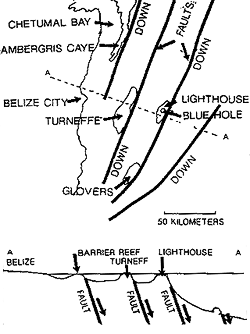 This illustration consists of a map and cross section illustrating the large faults off the coast of Belize that control the location of the large off shore atolls and to some degree the barrier reef. These faults are lowering blocks of the earth's crust into the sea over geologic time. The atolls are areas where limestone has been able to build up at a rate equal to, or greater than, the subsidence caused by movement on the faults. The bottom of the Blue Hole at Lighthouse Reef is 85 feet deeper than the last low sea level stand. This is because the fault has lowered the block the atoll is on. This blue hole is so huge, that it probably formed over several cycles of sea level changes.
 |
THE PLEISTOCENE AND GLACIATION
The Pleistocene is a time period which lasted from 2 million years ago
to between 8,000 and 12,000 years ago (depending on the geologist you are
talking to). The Holocene is the time from the end of the Pleistocene until
the present. The Pleistocene was a time of alternating ice ages and warm
periods, like today. The last Ice Age, the one that we are familiar with,
was the age of the woolly mammoth, sabre tooth tigers and cave painting.
During the last part of the Pleistocene there were actually five major periods
of glaciation with four periods of warmer non glacial conditions between
them. Since the last period of maximum glaciation some 18,000 years ago,
the ice caps and other glaciers have melted and retreated until they reached
there present configuration about 1000 years ago and sea level quit rising.
There is discussion among scientists as to whether or not we are going into
another glacial age or are just emerging from the last one. This is an important
issue, because if we are still emerging from the last ice age, then more
of the ice caps may melt and sea level may rise further, inundating existing
coast lines.
It is difficult for many people (including some geologists) to visualize
how sea level could drop that much just by expanding the ice caps. If one
could go back to the site of Chicago, Illinois, 18,000 years ago, you would
be standing on an ice sheet over two miles thick, and you would be in a
climate just like the Arctic is today. This ice sheet would stretch south
of You to southern Illinois and north across the northern United States
and Canada to the North Pole. Most of the Soviet Union and parts of northern
Europe were also covered. Ice age hunters were killing Mammoths on the floor
of what is now the North Sea. Groove marks scoured in bedrock by this ice
sheet now hold one fifth of the entire planets fresh lake water in the Great
Lakes of the northeastern United States.
AMBERGRIS CAYE AND SEA LEVEL
Now this all seems fine, but what you may ask is the relationship to
Ambergris Caye? The development of Ambergris Caye is tied to sea level and
sea level is controlled by major glaciation. As the last ice age began,
some 125,000 years ago, part of the water evaporated from the world's oceans
and fell as snow at the poles and in the northern parts of the continents
to slowly form ice caps and glaciers. The process of accumulating enough
ice and snow to form continental ice sheets is slow, and it took about 100,000
years. This left less water in the oceans since large amounts were tied
up in glaciers and ice sheets, and sea level fell. At the maximum extent
of the last glaciation, about 18,000 years ago, so much water was tied up
in ice that sea level was 390 feet lower than now. On the other hand, during
those periods between widespread glaciation, the water had melted from the
ice sheets and polar areas, flowed, back into the oceans and sea level was
as high or higher than now. Today, if just the current Ross Ice Shelf of
Antarctica melted, it is estimated that sea level would rise 20 to 251 If
we melted all of the ice on Greenland, the North polar areas and the Antarctic
in addition, sea level could rise 300' or so. It was during a time of higher
sea level that the ancestral barrier reef system off Ambergris Caye developed.
About 125,000 years age, between two ice ages, sea level was 20 to 25
feet higher than now and an ancestral barrier reef formed in approximately
the same location as the reef today, but the island of Ambergris Caye was
non-existent as we know it now. From the limestones exposed here and there
on the island, we know that it was instead an area of fairly shallow water
with areas of broken up reef material, patch reefs and areas of quiet water
with many of the same marine animals we see today, such as the Queen conch,
and many other snails and clams and such illustrated in this guidebook.
All these creatures lived and died over the years and their skeletons were
broken up by wave action and algal boring, just as is happening today. A
thick accumulation of this material built up on the sea floor (as is happening
here today) to form what would become the Pleistocene limestone of Ambergris
Caye. As sea level slowly dropped during the initial stages of the last
ice age, this ancestral reef and lagoon area became very shallow and then
was exposed as land. Rain falling on this material dissolved some of the
calcite skeletal fragments and then precipitated this calcite in between
other grains to cement all of the grains together and turn the material
into a limestone. As sea level continued to drop, the fresh water table
(which floats on sea water, since it is lighter) continued to drop and a
process called karsting began.
RED CLAY AND BLUE HOLES
Karsting is the dissolving of limestone over a long period of time to
form cave systems and enlarged vertical cracks called joints. This cave
system is still preserved as the numerous blue holes that dot waters in
and around the Caye. A blue hole is formed when part of the roof of a cave
collapses and a passage from the sea floor to the cave is formed. The enlarged
vertical joints give many creatures such as fish and moray eels a place
to live on the sea floor today. During this period of karsting, the top
20 to 30 feet of limestone was dissolved away, leaving a very irregular
surface on the remaining limestone. Limestone often contains a certain amount
of clay, especially if it was deposited in protected shelf or lagoonal areas
such as Chetumal Bay. As the limestone is dissolved during karsting, this
clay is concentrated in the soil that forms during this weathering. Several
of the savannahs in Ambergris Caye exhibit this red clay. There was probably
a lot more of it, but the Maya apparently may have used it in making pottery.
FORMATION OF CHETUMAL BAY AND AMBERGRIS CAYE
As the last ice age ended, about 18,000 years ago, the ice caps began
to melt and return their water to the oceans and sea level rose. About 7000
years ago, sea level had reached a point where it began to flood the irregular
limestone on the northern Belize shelf where Ambergris Caye is located.
As this area was flooded by the rising sea, a new reef began to form over
the old Pleistocene reef, Chetumal Bay was formed, and Ambergris Cay began
to form around a topographic high of Pleistocene limestone that was still
above sea level. Mangroves were able to root and grow in the shallow water
around the limestone outcrop, trapping carbonate sand and mud so that the
island began to form and grow, a process that continues up to today. At
Reef Point, several miles to the north of San Pedro, there is a well preserved
Pleistocene patch reef (that formed just behind the barrier reef) exposed
on dry land. The modern reef then is built upon an older reef system and
the island was formed by the trapping of carbonate sand and mud behind these
reef systems. Geologists come to Ambergris Caye to study the formation of
limestones and dolomites forming at the present time. Since many oil and
gas reservoirs occur in limestones and dolomites now buried thousands of
feet below the land surface, geologists who look for oil and gas need to
know how they formed and where to look for them.
GEOLOGY AND THE MAYA SITES
The geology of rising sea level also impacted heavily on the Maya. A
visit to the Mayan site of Marco Gonzalas on the southern end of Ambergris
Caye reveals a present day swamp, complete with mosquitoes, as the site
of a rather large Mayan town. When that city was being built over 2000 years
ago, sea level was at least 2 feet lower and there was no swamp. In addition,
since the island has been growing to the south, the town was very likely
close to the beach and cooled by the same breezes that air condition San
Pedro today. Marco Gonzalas was probably a very nice Mayan resort as well
as an important town on major sea trade routes. As sea level rose and the
fresh water table reached the land surface, forming a swamp, all that changed.
By 1000 years ago everything of any value had been moved to higher ground
and the town was left to jungle. Dr. David Pendergast of the Royal Ontario
Museum is supervising the excavations of Marco Gonzalas and believes it
will add a great deal of knowledge about the Maya and their trade routes.
Many of the Maya sites on Ambergris Caye have a very dark soil associated
with them. This black earth is the result of the organic refuse (composting)
added to the soil by the Maya during many generations of living and farming
at these sites.
MODERN IMPLICATIONS
The Maya may not be the only ones to suffer from the impact of rising
sea level. Since the industrial revolution civilization has been pouring
vast quantities of carbon dioxide into the atmosphere from the burning of
fossil fuels. Carbon dioxide in the atmosphere helps trap the suns heat
more effectively, and global temperatures have slowly been rising. in response,
glaciers and the Ross Ice Shelf have been retreating. Just a few months
ago, an iceberg twice the size of Rhode island broke off this shelf and
is floating north toward warmer waters. Sea level has starting rising again
and is currently rising about 1 inch every thirty to forty years. This rising
sea level may be contributing to coastal erosion that is occurring in so
many areas of the world today, including Ambergris Caye.
BEACHCOMBERS TIP:
The Pleistocene bedrock is exposed on the leeward parts
of the island and the local Mayan name is "chauay". It has been
eroded by the action of rainfall and ground water into a very irregular
and sharp surface. These exposed rocks are all limestones containing fossils
of corals, clams and snails. 
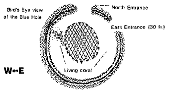 This Blue Hole is the result of the repeated collapses of a cave system formed during lower sea level stands. The reason that the hole is 475 deep instead of the shallower 390 foot depth is that this atoll is on a geological fault block that has been subsiding into the basin through geologic time.
 |
Ambergris Museum
This information courtesy of R. L. Wood, S. T. Reid, and A. M. Reid, and their
book
"The Field Guide to Ambergris Caye"
|