
Rina Weakens to a Tropical Storm
Accuweather
Oct 28, 2011 5:28 AM
Rina to Keep Harassing Cancun
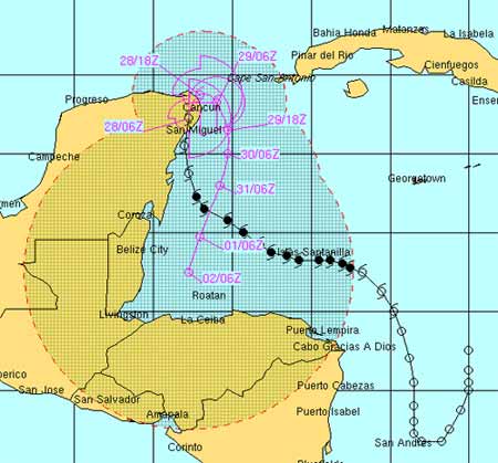
Tropical Depression Rina is located at 21.8° N, 86.6° W with maximum sustained winds of 35 mph, gusting to 45 mph
Slow-moving and meandering Rina will continue to impact eastern parts of the Yucatan Peninsula and western Cuba for days.
Rina continues to weaken. However, it is expected to slowly move north along the coast of the Yucatan Peninsula this morning. The main threat from Rina is rainfall. Another 1-2 inches of rain is expected to fall across Cancun and Cozumel during the day Friday. Wind gusts could be locally strong, but Rina's winds will continue to diminish as the system weakens. The satellite picture continues to show Rina weakening. The center of circulation is now to the south of the strongest convection thanks to strong upper-level wind shear. The convection will continue to be ripped away from the low-level center of circulation today as shear is not expected to change much. This will leave nothing more than a low-level swirl of clouds by the weekend, when eventually Rina will turn around and begin to drift south and back out over the Caribbean as a remnant low.
We have also been monitoring a tropical wave over the southern Caribbean. Although the wave is producing widespread showers and thunderstorms, development into a tropical system appears unlikely for the next several days.
A third system, a low pressure center to the west of the Cape Verde Islands, is producing an area of area of showers and thunderstorms; however, due to wind shear aloft, it is currently not expected to develop into a tropical cyclone anytime of the next couple of days.


