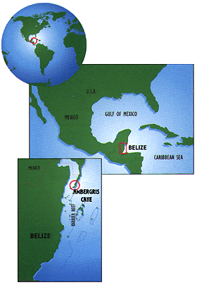
General Information and Maps for
|
|
|
This page relates mainly to Ambergris Caye and San Pedro Town, for extensive information on Belize click here.
While politically part of Belize, Ambergris Caye has more in common, geographically and culturally with Mexico's Yucatan Peninsula. If the Maya hadn't enlarged and dredged a canal at the north end of the caye, Ambergris Caye might be part of Mexico today.
What's a "fact" when describing a culture? So the "facts" here are/will be opinions that we welcome you to challenge and improve.
 |
| |
The island is a 25 mile long, flat, coral sand island, protected on the east by a living reef that extends 185 miles down the coast of Belize. Ambergris is the southern most extension of the Yucatan Penisula, a unique Penisula of porous limestone.
Ambergris Caye is a narrow island with the lagoon on the west and the reef on the east. San Pedro Town is the only town on the island, located at a narrow point of the island, and from the air traveler's perspective, right at the end of the runway. Click here for fairly complete descriptions of the major areas of Belize. Southern Barrier Reef Islands, Atolls, Northern Atolls, and Mainland areas.
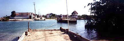
The cut between Mexico and the caye is narrow, over most of its length it's no wider than a boat, boat and a half. It's natural, and not dug by the Maya. You see, it's very winding, and its margins are in mangrove peat and clay. As smart as the Maya were, I'd imagine they'd have dug a straight canal, for as it is, it's about 4 times longer than a straight canal would be. Why would anyone want 4 times the work? Such channels are normal tidal channels that allow exchange of water between the outer shelf and inner shelf during tidal cycles. The cut up north is just as winding as Boca del Rio, both of which are natural features. The idea that such channels were cut by the Maya is a local legend, made "true" by virtue of repetition.
Climate:
Ambergris Caye enjoys the sun and heat of the tropics, but is cooled by the trade winds off the Caribbean Sea. Temperatures range from 75 - 95 degrees in the day, year round. The rainy season is May to February, with most of that falling in late afternoon and evening.
While southern Belize may get up to 140 inches of rain per year, Ambergris Caye only receives about 40 inches per year. It would be a rare tropical vacation here that didn't have more sun than you could want. The water temperature is almost always around 82 degrees.
North America takes great pride in enjoying its four distinct weather patterns: Spring, Summer, Autumn and Winter.
In Belize, we also celebrate the on-set of our four seasons, but not necessarily in that order. Our seasons should be classified as such:
1. Breezy (January - April),
2. Rainy (May - July),
3. Mosquito (August - October) and
4. Cool (November - January).
 Flora and Fauna:
Ambergris Caye was once a part of Mexico and therefore its wildlife is vastly similar to that found in northern Belize and southern Mexico. Plant life for the most part consists of White, Red and Black Mangrove, Buttonwood, littoral forest plants such as black poison wood, red and white gumbo limbo, sapodilla, ziricote, wild sea grape, fig, copal, coco plum, coconut, saltwater palmetto, and several small shrubs.
 Fauna includes over 200 species of bird including endangered birds such as the black catbird. Common sightings include the white-eyed vireo, Yucatan vireo, common tody flycatcher, great Kiskadee, black and gray catbird bird, chachalaca, cinnamon hummingbird, parakeets, black hawk, yellow-bellied elaenia, laughing falcon, white collared seed-eater,, golden-fronted woodpecker, black-headed salator, blue herons- egret birds, roseate spoonbill and the hooded oriole.
 Less frequent visitors to the Caye include green-breasted mango humming birds, yellow-backed oriole eastern kingbirds, scarlet and summer tanagers, regal white-crowned pigeons and the rose-throated becard. The'northern end of Ambergris Caye is also home to many other terrestrial wildlife such as peccaries, raccoons and white-tailed deer. Some locals have even reported seeing jaguars!
For more information, see the Ambergris Caye Field Guide.
CLICK HERE for our new map area! Complete with thumbnail images of the maps... Click here for a map of the Southern USA, Caribbean & Central America with travel routes to Belize. Click here for a great map of Belize with many roads and parks marked. Click here for a second great map of Belize. Click here for a geographical relief map of Belize and the surrounding area. Click here for a geographical relief map of the Bay of Chetumal and the northern area of Belize including Ambergris Caye. Click here for a detailed map of many of the businesses of Ambergris Caye and the downtown area, plus maps covering north of town and south of town.
Click here for a great map of the island by Sal Mazzullo, PhD, who has studied the geography of the island for decades. Click here for another one of Dr. Sal's maps, this one of the dive sites in the area. Purchasable 2X3 feet. Click here for one of Dr. Sal's maps of the localities/ geographical areas of Ambergris Caye. Purchasable 2X3 feet. Click here for one of Dr. Sal's maps of Belize, very detailed and with many Maya sites marked. Purchasable nine by eleven inches. Click here for a very detailed map of the island area and the lagoon to the west. Click here for a map of the southern end of the island around San Pedro. Click here for a map of the original land grants and the 83 families who received them. Courtesy George Parham. Click here for a map of many of the streets downtown, with some businesses marked. Click here for a map of Ambergris Caye with the general areas of the island identified. Great for real estate hunting. Click here for our online store. Maps for much of Central America are available. Click here for Belize Economics & Investment Guide. Also has a maps page. Click here to download an awesome map of the island. Courtesy of Triton Properties, it is a 1.2 mb file that is suitable for printing. The map is 10 inches by 16 inches and 150 dpi. It is in JPEG format, so load into Photoshop or other image manipulation software. Will not load into browser (Netscape). Too big of an image. Click here to see a map of the island with dive sites marked. Shows mangroves, reef sand flats, and reef crests as well as the land areas. Click here for a political map of Belize. This map shows the various villages, towns and cities in Belize as well as major highways, rivers, islands and elevation of the country. Click here for a physical map of Belize. This map shows the various villages, towns and cities in Belize as well as major highways, rivers, islands and elevation of the country. Click here for an antique map of Belize and Central America. This map shows a 19th century map of Belize and all the countries in Central America. Click here for a Belize and Central America map. This map shows Belize and all the countries in Central America. Click here for a Belize and Central America relief map. This map shows a physical relief view of Belize and all the countries in Central America and the Caribbean. Click here for a Spanish language super detailed map of Belize and most of Guatemala. Very large map (1.32mb). Includes an area formed by a square between the cities of (clockwise from upper left) Santa Amelia, Guatemala; Corozal and Consejo Belize; San Pedro Sula, Honduras; and Coban, Guatemala
Click here for an 18th century map of Belize and Guatemala. The 1/2 mile from the beachline to the reefline has an abundance of wonders. Click here for detailed information about this area. A detailed list of the various mammals, invertebrates, fish, birds, and other creatures that inhabit these waters can be read by clicking here. Click here for a thorough examination of the plant life on and around the island. The tree, bushes, underwater grasses, a botanical sweep of the island... For super detailed nautical maps of Belize, contact Wescott Cove Publishing Co. Box 130 Stamford, CT 06904, 203-322-0998
|

